![]()
The Swinford Charter (S579) of AD 951-9:
A new interpretation of the boundary clause
and
thoughts on the origin
of Oldswinford and Pedmore parishes
by
K James BSc(Hons) MSc PhD FIAP
|
TWO VERSIONS ARE AVAILABLE TO DOWNLOAD:
The Swinford Charter
of AD 951-9, revision 02/12/13 Approx. 19 Mbytes, 40 pages, 9 figures, 15 photographs
The Swinford Charter
of AD 951-9, revision 17/07/17 Approx. 23 Mbytes, 57 pages, 12 figures, 16 photographs
To read the PDF document you will need a copy of Adobe Reader, which is available from Adobe's web site by clicking the button below.
|
DOCUMENT SUMMARY:
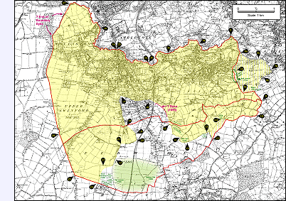
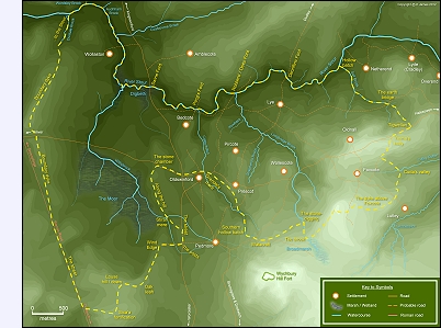
The Swinford charter represents the grant of a parcel of land, by King Eadred, to his minister Burhelm. The charter estate (i.e. the land granted to Burhelm) was carved out of a larger region called Swinford, which encompassed the present-day areas of Kingswinford, Stourbridge, Lye, Wollescote, Oldswinford, Norton and possibly Pedmore - all now part of Dudley Metropolitan Borough in the West Midlands.
 The bounds of the land conveyed to Burhelm are described in
the charter's boundary clause by means of a series of waypoints or landmarks.
Together these seem to represent an area which is approximately coincident with
(most of) the ancient parish of Oldswinford and which may, arguably, extend
eastwards and southwards to include parts of Cradley and Pedmore as well.
The bounds of the land conveyed to Burhelm are described in
the charter's boundary clause by means of a series of waypoints or landmarks.
Together these seem to represent an area which is approximately coincident with
(most of) the ancient parish of Oldswinford and which may, arguably, extend
eastwards and southwards to include parts of Cradley and Pedmore as well.
The charter is written in Old English (OE) and, as many of the landmarks referenced therein no longer exist today, interpreting the boundary clause presents a number of difficulties.
Several different interpretations have been published by academics and local historians (i.e. GB Grundy, 1928; RL Chambers, 1978; D Hooke, 1990; E Richardson, 1997 and J Pritchard, 1997+); and two of them (Dr Hooke and Dr Grundy) provided their own translations from OE. In some important respects there is little consensus between the various investigators on the exact course of the charter estate's boundary, particularly along its southern edge.
 The document available here proposes a new route for the
charter bounds. This is based upon many of the aforementioned researchers'
published notes (particularly the translation provided by Dr D Hooke in her 1990
book
Worcestershire Anglo-Saxon Charter Bounds) as well as some additional
observations from new map and field work. Several new conjectural landmark
identifications are described. These correspond well with the available
landscape evidence, and result in a continuous and logically explainable
boundary route that deviates significantly from the pattern of later parish
boundaries.
The document available here proposes a new route for the
charter bounds. This is based upon many of the aforementioned researchers'
published notes (particularly the translation provided by Dr D Hooke in her 1990
book
Worcestershire Anglo-Saxon Charter Bounds) as well as some additional
observations from new map and field work. Several new conjectural landmark
identifications are described. These correspond well with the available
landscape evidence, and result in a continuous and logically explainable
boundary route that deviates significantly from the pattern of later parish
boundaries.
The charter estate appears to encompass approximately two thirds of the ancient parish of Oldswinford and about half of Pedmore parish as well. There is also an indication that the ancient agricultural area around Oldnall hill in Cradley might have been included within the charter estate's eastern boundary. However, the most interesting finding of this study is that the estate appears to have excluded the settlement centre and agricultural fields of Oldswinford.
 This is unexpected. It had been thought by some
researchers that the charter
represented the beginnings of Oldswinford manor and parish, but the charter
estate's markedly different
boundary pattern would seem to cast doubt on this idea. Only the
western and northern boundaries coincide; but, as these boundaries entirely
follow prominent landscape features that pre-date both the charter and the parish, this coincidence is
perhaps unsurprising.
This is unexpected. It had been thought by some
researchers that the charter
represented the beginnings of Oldswinford manor and parish, but the charter
estate's markedly different
boundary pattern would seem to cast doubt on this idea. Only the
western and northern boundaries coincide; but, as these boundaries entirely
follow prominent landscape features that pre-date both the charter and the parish, this coincidence is
perhaps unsurprising.
The pattern of local manors and parishes probably developed in the late tenth or the eleventh century as a result of some form of local territorial restructuring overseen from a position of high authority. This clearly resulted in the major settlements - i.e. Oldswinford and Pedmore (and perhaps Hagley) - being assigned their own share of the local landscape. The intent might have been to roughly equalise each territory's size and value; and it is conceivable that Amblecote and the settlement of Oldswinford were added to the charter estate at this time in order to compensate for the loss of land in (the later) Pedmore parish and (possibly) Cradley. The division of Oldnall and Wychbury hill fort by the local parish boundaries might be evidence of a distribution of resources or of some compensatory element in the restructuring process.
|
Comments and Discussion Whether you have a professional or amateur interest in this subject, comments and criticisms are welcome. To discuss this article you can contact me by email at kjames_sd@hotmail.com or post a message on either of the following discussion forums:
HOW History of Wollaston Group
Worcestershire Local History Forum At the latter Forum, click on the 'Projects and Research' category, then 'The Swinford (Anglo Saxon) Charter' topic.
Thank you to everyone who has commented so far.
|
||